Area: 110,922 sq km (42,803 sq miles)
Population: 11,423,952 (2008)
Capital: Havana
Language: The official language is Spanish. Some English and French are spoken.
Religion: Roman Catholic majority
Time Zones: GMT -4 (GMT-5 October to March)
Electricity: 110/120 volts AC 60Hz
Passport: Valid passports are
Currency: Cuban Peso (Cub$) = 100 centavos
Health: Special precautions: Typhoid & Polio
Climate: Hot subtropical cllimate the whole year. Most rain falls between May and October and hurricanes can occur in autumn (August to November). Cooler months are November to April when the least rain falls.
Travelling in Disaster Prone Areas
International Dialing Code: 011+ 53 + area/city code
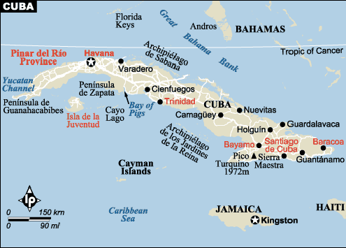
Cuban Geography:
Cuba is the largest Caribbean island and the most westerly of the Geater Antilles group, lying 145km (90 miles) south of Florida.
West of Havana,in the Pinar de Rio province, is the narrow Cordillera de Guaniguanico mountains extending 180 km which is made up of the Sierra de los Organos, Sierra del Rosario and Alturas de Pizarras. Here the finest Cuban tabacco is grown. The Sierra Escambray Mountains, located south of the provinces of Villa Clara, Cienfuegos and Sancti Spiritus, rise to 1140m. Encircling the port of Santiago de Cuba are the rugged Sierra Maestra mountains where the highest peak can be found, Pico Turquino rising to 1972m. A quarter of the island is covered with mountain forests of pine and mahogany.
Pulsating African rhythms, supple Mediterranean tones... Santeria holy men who can predict the future... Food by a ticket system... In Cuba which slid with surprising speed into socialism after the revolution new winds of change are blowing. Even if only on a small scale trade is now free.
The battle for freedom is never ending in Cuba: first against slavery, then the Spanish colonialists and then against America. This time a war has begun against the economic sanctions imposed by America. With the defeat of Cuban dictators came economic embargos, and two short words remind the world of the importance of this long road to freedom: Cuba libre, free Cuba...More
Map of Cuba