Area: 8,866 sq. miles including 266 sq. miles of islands
Population: 301,270 (2008)
Capital: Belmopan
Language: English
Religion: No official religion mostly Christian
Electricity: 110 volts
Passport: Valid passport and visa except USA
Currency: Belize Dollar
Temperature range: 10C to 35.6C
A valid passport is necessary for entry into Belize . United States citizens are not required to have travel visas but citizens of most other countries will need a visa. Visitors are permitted to stay in Belize for a period not to exceed thirty (30) days. Extensions for another thirty (30) days can be obtained at Immigration offices located in Punta Gorda, Belmopan , Orange Walk, Big Creek, Dangriga and Belize City at a cost of US$12.50. Only three extensions are allowed for a total of ninety (90) days. If you would like further information about Belize, please visit bzecotourism.org.
The currency unit is the Belize dollar (BZ$). There is a fixed rate of exchange of BZ$2 to US$1. The four banks of Belize; Belize Bank, Barclays Bank, Atlantic Bank, and the Canadian based Bank of Nova Scotia will cash travelers checks, give cash advances on Visa or Master cards and have wire transfer services. Hours of operation generally are 8:30 AM to 12:30 PM. five days a week. On Fridays they stay open longer.
Philip S. Goldson International Airport is situated 10 miles from Belize City . Regular international services are maintained by three major airlines, TACA from Houston , Miami and Los Angeles , American Airlines from Miami , and Continental from Houston . Continental has two flights a day from Houston during the busy season, December to May. Taxi fare from the International airport to Belize City is a standard $US15.
Telephone communications are provided by Belize Telecommunications Limited (BTL), a private company, which owns the telephone service that covers all of Belize . A cellular network has now been introduced and is available throughout much of the country. BTL provides telephone, direct dial and Internet connection services.
113 for local directory assistance
114 for local and regional operator assisted calls
115 for international operator assisted calls including calling card calls 911 for emergencies
Electricity in many places is provided by diesel generator equipment. Power is at 110 volts AC, which is the same as in the United States . A small surge suppresser is recommended for computers and other sensitive equipment. Climate is sub-tropical, tempered by trade winds. Extreme temperatures in coastal districts range from about 10C (50F) to about 35.6C. (96F). Inland the range is greater. Belize has an annual mean temperature of 79 degrees Fahrenheit. Rainfall varies from an annual average of 50 inches in the north to 180 inches in the extreme south. The dry season usually extends from February to May with a possible dry spell in August. The official hurricane season is from June 1 to November 30.
Hiking boots or shoes with good tread.
Long pants and sleeves for hiking and evenings.
Short pants and cool cotton clothes.
Light weight rain gear with hood, bathing suit and sun hat.
Sun screen and insect repellent.
Binoculars and camera with plenty of film.
Flash light or head lamp.
Valid Passport and necessary visa.
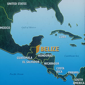
Belize (formerly British Honduras) lies on the east coast of Central America, bounded on the north and northwest by Mexico and on the south and west by Guatemala . The shallow coastal waters are sheltered by a line of coral reefs, with many small islands called Cayes (pronounced keys). Total land area of Belize is 8,866 sq. miles including 266 sq. miles of islands. This is roughly the size of Massachusetts.
A low coastal plain, much of it covered with mangrove swamp, typifies the coastline. Although the mangrove Cayes are normally uninhabitable by humans, they provide a superior habitat for birds and marine life.
The low-lying plain to the north, once under water, is swampy near the coast but rises to a slight plateau in the west. Today the terrain is crisscrossed by waterways and much of the Corozal and Orange Walk Districts are heavily cultivated in sugar cane.
Central Belize 's sandy soil supports large savannas. The Rio Bravo Conservation Area is located here. This area, largely uninhabited and supports an abundance of wildlife.
Southwest from Belize City the land begins to rise gradually towards the interior. The Cayo District in the west is home to the Mountain Pine Ridge at 305-914 meters above sea level. The Maya Mountains and the Cockscomb Range form the backbone of the southern half of the country and is the western border of the Stann Creek District. Victoria Peak in the Cockscomb Range is the highest point in Belize at 1124 meters above sea level.
Southern Belize , which is in the Toledo District, consists of many steep rivers carrying sand, clay, and silt, which have enriched the coastal belt over the years. This has allowed the area to develop significant agricultural products such as citrus and bananas. Along with an annual rainfall of some 170 inches, southern Belize has a true tropical rainforest that is rich with ferns, palms, and tropical hardwoods.
To rent a vehicle in Belize is easy and most companies have good support services, although the price tends to be a bit high compared to prices in the U.S.
There are 5 major highways in Belize ; the Northern, the Western, the Manatee (Coastal), the Hummingbird, and the Southern. Of the 5, only the Manatee and Southern highways remain unpaved. They are all weather gravel roads but they can be bad in the rainy season.
If you want a great way to explore Belize , renting your own vehicle is a good way to go. The country is so small that even if the roads are bad, nothing is too far away.
Most of the rental companies have two offices, one located in Belize City and the other at the international airport. This can be a real convenience eliminating the need to find transportation for the 12 miles into Belize City . It is also a nice feature when departing at the end of your visit as the vehicle can be checked in at at the international airport. You only load and unload your luggage once.
There is one rental company in Belize that will allow their vehicles to go across the border into Guatemala for those wishing to visit the ancient Mayan city of Tikal or go to the island city of Flores . For more information, contact us. (Our last trip to Tikal is documented here.)
Most rental vehicles have AC and stereo cassette decks. Available vehicles include Ford Ranger pickups, Geo Trackers (2 and 4 wheel-drive), Isuzu Sidekicks (2 and 4 wheel drive), Nissan Pathfinders, and 12-15 passenger vans.
The Hummingbird Highway is currently being paved with an expected completion date of late 1999. The Southern Highway from Dangriga to Punta Gorda is under contract to be paved over the next few years. With the exception of the Manatee Highway , all the major roads in Belize will be paved.
Round trip flights leave twice daily from Belize City international airport for the 45 minute flight to Santa Elena , Guatemala . From Santa Elena it is easy to arrange transportation to Tikal or to the town of Flores.
Rental vehicles can be driven across the Guatemalan border from Belize . The road is paved except for a 15 mile section after crossing the border. From Belize City to the site of Tikal or the village of Flores will take about 4 hours, including the border crossing. If staying in the San Ignacio area in western Belize , it is about a 2 hour trip. Early risers can explore Tikal in a day trip, returning to Belize in the afternoon.
Many of the lodges, resorts, and hotels in San Ignacio offer, or can arrange, day trips or overnight trips to Tikal. Usually included is transportation, lunch, and guided tour.